Day 1, and 2, and 3 spent at the Planet Lodge in Arusha. No, that's not Kilimanjaro in the background, it's Mount Meru, at 14,977 feet it's higher than Mount Whitney. We should have been going for a warm-up hike on the lower slopes of the mountain on day 2, but we still had only the clothes that we were wearing when we got off the plane and those weren't meant for hiking. Note to self, on future hiking treks the hiking boots and minimal hiking gear will be either on my person or in my carry-on...

So here I am, sitting around the lodge writing in my journal about how Lufthansa, Ethiopian, and Emirates airlines lost and couldn't or wouldn't locate and forward our bags to us. The problem started in San Francisco where Lufthansa said that they could only check our bags through to Addis Ababa where we would have to claim them, go through customs, and then recheck them to Nairobi. All might have gone well if we had flown to Addis as intended, but our connecting flight from Munich to Frankfurt (where we would have boarded an Ethiopian flight to Addis) was cancelled. We were rerouted through Dubai and then on to Nairobi on Emirates, but our bags went to Addis Ababa and stayed there. Like I said, none of the airlines was at all helpful in locating our bags or getting them to us. It took the hard work, perseverance, and incredible generosity of Roseanne, the guest relations manager at the Tribe Hotel in Nairobi, who made many calls and visited the airport on our behalf even after we had checked out of the hotel and moved on to Arusha. Roseanne, you are a saint!

Dave started looking a bit scruffy because his razor was in the checked bags. After a number of ups and downs about locating bags - first the word was that they found only mine (the yellow bag) so Justin (our Kili guide) drove us around Arusha (day 2, the planned Meru warm-up day) so that we could rent some gear for Dave. That evening the word came back that no, it's not the yellow bag it's the black bag - Dave's gear. OK, so the next day (day 3 when we should have been starting the climb) we go out shopping to find gear for me. And as soon as I've bought new gear we get the message that - oh can you believe this - BOTH the yellow and black bags are arriving that afternoon. So just to make sure that the bags didn't get lost en route to the lodge we make the trip to the airport ourselves to claim the bags. Ah, but where's the green bag with all the safari gear? Who knows, but at least we can start the climb the next day.

The climb is truly finally starting, we've signed in at the Landorrossi gate.

Words of warning.

Our crew of 14 porters, 1 cook, and 1 assistant guide met us at the ranger station (18 guys and me).

There's some of the stuff that will be hauled up the mountain for us.

The area around the ranger station and the lower slopes of Kili are very rich farmland and managed forests.

The start point for the actual hiking is about an 8.5 mile drive from the ranger station, a good chunk of it on extremely rutted dirt roads that we would have had to hike if it had been too wet. We're starting at an elevation of about 7800 feet and will hike about 3.2 miles to an elevation of about 9200 feet. (Note about the elevation charts - the times are all 11 hours off because the time shown is Pacific Standard Time - I'm not sure why, the device was showing local time when I was hiking. Some of them also have what appear to be very steep initial climbs, but that's just because the device took a while to find the correct elevation after I turned it on, it always seems to start low.)
Day 1, Lemosho Glades to Big Tree Camp

The first hike of the trek starts here at Lemosho Glades. We'll be hiking the Lemosho Route to Big Tree Camp on day 1.

But not before we have some lunch. We were incredibly well fed on this trip - all you can eat and then some. It's amazing what Eliudi (not sure about how to spell his name) could whip up.


Fireball Lillies (Scadoxus multiflorus)

Lobelia, don't know what species.

Our assistant guide Tumaini told me what species it is, but of course I've forgotten.

The rainforest zone on Kili gets a lot of rain but it stayed dry for us while we hiked. We had a cloudy day and it was a bit humid but not at all uncomfortable for hiking. We had a bit of rain late that afternoon after we got to camp but not enough to make it too soggy,

The porters carry everything needed for the trek, including their own gear. Most of them carry a small pack for their own stuff and then the camp equipment and our gear on their heads or shoulders. All we had to carry was a daypack with lots of water and anything else that we might want while on the trail. These porters were with a different group. Our guys had already gone ahead to set up camp, we lagged along behind going pole-pole (swahili for slow), one of the keys to properly acclimate and avoid altitude sickness.

The amount of weight that a porter is allowed to carry is strictly limited (about 30 pounds) and their loads are weighed at the first and second camps. Here's a group waiting to have their loads weighed.

Dave had some fun with the guys when he asked them to check his own weight.

Relaxing in our dining tent and keeping up with my journal. The porters were always well ahead of us and usually had camp all set up by the time we got there, at the very least the dining tent, our sleeping tent and our potty was set up. Not long after we arrived we were always presented with a basin of warm water to wash up.

Not the best photo, but our only one of what I think is a Tree Hyrax. Cute little thing.

One animal that we couldn't get a good photo of was a Colobus monkey. We did get an earful though, I woke up at least three times that night to the sound of them calling to each other in the trees overhead. The sounds seemed to come in waves, from one side of the camp to the other, back and forth. It's hard to describe what they sound like, something like a cross between a sneeze and a cough but long and drawn out - very alien sounding.
Day 2 we climb up to the Shira Plateau.

The next day we climbed out of the rain forest and into the heather or moorland zone.

Can you see the porters on the trail?

Lunch time! Eliudi prepared our lunch at breakfast and carried it up the mountain in a container that kept it hot. Pepper steak and pasta, along with cheese, tomatoes, cucumbers, and fruit. And always hot drinks like tea, coffee, cocoa.

This strange thing is an ants nest.

Views back.


Some sort of everlasting flower, or paper flower as Tumaini called it.

Another flower, id unknown.

Coming into Shira 1 Camp.

Malachite? Sunbird

White-necked Raven. The ravens were scavenging in every camp.

Our assistant guide Tumaini.

Some hikers stack rocks along the way - it's supposed to bring good luck to ensure that you make the summit. We saw stacks here and there all the way up the mountain.

The ranger station at Shira 1 camp where the porters' loads get weighed again.

And we have to sign in again. There are no more weigh-ins or sign-ins after this camp. I guess they figure that if you've made it this far you're here legitimately. The rangers spend 10 day shifts in the camps and then get to go down the mountain for a while.

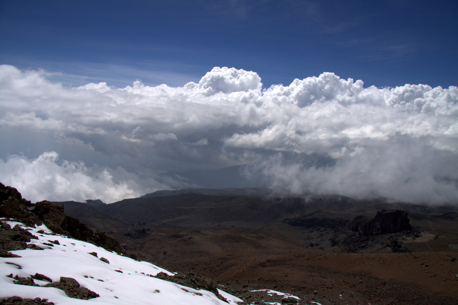
Oh wow, one of our first good sightings of Kibo. The mountain has been covered in clouds each afternoon, the pattern has been that the day starts clear and then clouds gather over the mountain through the day and then the clouds suddenly disappear just before sunset. We're headed to the low spot in the crater wall, the Western Breach,. We'll climb up the breach and then the height on the right. Uhuru Peak (the highest point on Kili) is out of sight on the right.


Lobelia.

Taking a break along the trail. That's our guide Justin.

Day 3, We cross the Shira Plateau.

We set out across the Shira Plateau towards our next overnight at Moir Hut.

Up here the climate zone changes to Alpine Desert. Only the hardiest plants can survive the freezing nights and hot days. Fortunately, we didn't have to endure such extremes, we had cool daytime temperatures and woke up to frost in the morning.

Lunch on the trail again. I felt like I was constantly eating.

Not all the signs are well maintained.

One common life form was this strange orange lichen that looked like beards hanging from the rocks.


Dave just couldn't stop talking while we were hiking, at least until we got to a certain altitude...

A lovely green grotto along the way - it really stood out in the barren rocky alpine desert.


Moir camp. There was only one other group staying the night, they had the green tents and the blue one on the far left. Dave and I were sleeping in the orange dome shaped tent, the gray tent to the left was our potty, we got to use a portable sit down throne. The brown tent was our dining tent, the blue and gray tent was where Justin and Tumaini slept, and the other two dull orange tents were the cook tent and the porters' tent. The triangular structure in the background on the right is the ruined ranger hut.

I've started to wear my down parka at this altitude, it's definitely getting colder. I also put on my light weight wool long undies under my hiking pants.

We did a short climb up to a higher elevation to help acclimate to the altitude. This spot also happens to have cell phone reception...

More stacked rocks. The landscape is really quite barren now, there isn't much that will grow up here.

Looking down on Moir camp.

We were camping at about 13,700 feet and took a short hike to about 14,100 feet to help us acclimate to the altitude. Dave and I are both getting headaches, especially when we lie down, but we're free of other symptoms of altitude sickness. The headaches go away when you get up in the morning and start moving around.

The afternoon clouds are shrouding the mountain.

And then the clouds disappear!

But not before we get some rain and hail dumped on us.

Carduus keniensis

We awoke to a frosty landscape the next morning.

Day 4, we climb to Lava Tower camp.

It's only about 3 miles and 1600 feet of elevation gain to Lava Tower camp, but we passed the highest elevation that we've ever hiked to, Mount Whitney is about 14,500 feet high and Lava Tower camp is at about 15,200 feet. We hiked an additional 400 feet up and down to help acclimate. So far we are still free of altitude sickness other than headaches.

Lava Tower can be seen on the left, the camp is at the base.

Up and up, we are still going very slow, something like 1.5 miles and hour.

Dave was quiet on the trail today, the altitude is finally slowing him down.

There's Lava Tower on the left. You can see the wet trail looking like a ribbon across the landscape. We were fortunate and didn't have to hike in the rain. The rain always seemed to hold off until after we got into camp so we could stay dry in the tent.

This sign is in better shape.

The clouds are allowing a glimpse of Kibo.


Closer...


Almost there...

Now we are up in the clouds instead of looking up at them.

This is the view looking back at Lava Tower when we went out on our acclimatization hike.

We got the primo spot right at the base of the tower. The group that camped with us at Moir Hut spent the night here also. A lot of groups come to Lava Tower and stop to have lunch and then hike down to Barranco camp at a lower elevation to spend the night. When we first got into camp it looked like a tent city and then by mid-afternoon it was just us and the other group.

Snow instead of rain last night.

Day 5, we climb to Arrow Glacier Camp.

The hike up to Arrow Glacier Camp is really short, less than a mile and only about 800 feet of climbing. We tacked on about another 200 feet of climbing up the trail that we will be taking the next day for acclimatization. The short hike meant that we could sleep in until 8:00 and hit the trail at 10:00.


After a rest in camp after lunch I found the energy to climb above the camp for a look around and to take some photographs.

That's the start of the trail that we will be taking tomorrow. We will be hiking/climbing up the Western Breach which is on the left.

Lava Tower is not far away. The group that spent the night with us there did not join us in Arrow Glacier camp.


Another look at where we will be climbing the next day, the Western Breach.

The air is clean and the light is incredibly brilliant up at this altitude.


There are ice formations up and down the cliff.
Thank goodness we're not climbing that!

Tomorrow is summit day and we have a 4:30 AM wake-up and then hit the trail at 5:00 AM so it's an early dinner and early to bed.

Day 6, summit day.
A really big day because we have to do what should have been 2 days of climbing/hiking in 1. The original itinerary was to climb to Crater Camp on Day 6 and spend the night in the crater and then do the last 700 feet of climbing to the summit on Day 7 and then cruise down to the last camp at Mweka Hut. We get a bit of a break because we are spending the last night at Millenium Camp which isn't as far down the mountain.

I was really glad that we got to bed extra early. It snowed all night and accumulated 5 inches. Our tent couldn't stand up to the accumulation and nearly collapsed on us. I had to go outside in the middle of the night and brush the snow off the tent, it was too heavy to knock it off from the inside.
We got our 4:30 wake-up and simply got up and dressed - for me that was both my light and mid-weight long wool undies, warm hiking pants, gaiters, and rain pants on the bottom. On top I wore my warmest wool base layer, Rab hiking shirt (one of my favorite pieces), mid-weight jacket, and rain jacket. Wool hat, helmet, and headlamp to cap things off. A quick breakfast and we hit the trail.
I'm not sure how Justin and Tumaini found the way in the pitch black dark with 5 inches of new snow covering the trail. When it got light I did notice some markers such as buckets filled with rocks or crossed sticks along the way and there must have been others that I didn't see in the dark because all I was looking at was the footprints that I was following.
The distance to the rim of the crater was actually not that far, about 2 miles, but we had to climb about 3,000 feet, often times scrambling up snow covered rocks. It was really difficult to get solid footing in the slippery snow, even with Tumaini and Jared (one of our porters who carried the emergency equipment and lunch) clearing a path ahead of us. The thin air made it really difficult to breathe, I found myself taking a couple of steps and then stopping to catch my breath. Every time I had to scramble up a few rocks I had to stop and pant to catch my breath and ease my queasy stomach. Long before we reached the rim I was relieved of the weight of my backpack by Justin as was Dave by Jared. Those guys are amazing, carrying their own full packs and ours as well.
Finally, after 6 hours of slogging up the mountain through the snow we got to the rim of the crater. Time for a break! And the camera came out of the pack for the first time that day. I wish I could have managed to get a snack down, I really needed the energy, but my stomach was too queasy.


It was windy at the top and the snow was fine and icy. My face took a beating from the blowing snow. I had sunscreen on, but it didn't seem to help much, it was probably scrubbed off by the snow that was blown on my face. If I'm ever in the same kind of situation I have to remember to wear a balaclava. At least I had glacier glasses to protect my eyes - the sun was so intense, truly blinding.


That's the way up...

Nearly there...


We finally made it!

The top at 19,371 feet.
We climbed about 3700 feet over 3.1 miles and it took only 8 hours and 9 minutes.

I took some time at the top and down toward Stella Point to take some photos and then I put the camera away because I needed all my remaining energy and strength to get down to Millenium Camp. Dave and I both were exhausted from the long climb and little food. This day was the most difficult that I've ever experienced hiking, or for that matter, any physical endeavour.
Looking down into the crater.

The way we had just come.
We were the only group to climb the Western Breach that day.


I did take a couple of photos of the trail on the way down. It was not as pretty as the snow covered mountain top, just rocky and beaten down by the thousands of hikers that tackle the mountain by this route.

When we finally got to camp at the end of the day after hiking another 5.5 miles for 4.5 hours - for a total of over 8.5 miles and 12.5 hours, we were so tired that we barely had the strength to wash up, blow up our mats, fluff our sleeping bags before crawling into them. I think that Dave kept most of his clothes on and just conked out. We did get the good news that our third bag had been found in Addis Ababa and was being rushed to Arusha the next day. Dinner was brought to us in our tent a while later but Dave was too tired to eat and I barely got about half of it down.
Day 7, the hike down to Mweka Gate.

It was all downhill from here, which sounds easier than it was. Our legs were still wobbly from the day before and we would not have made it down the mountain without our trekking poles.
Kibo seen from Millenium Camp on our last day.


The first half of the trail looked more like a riverbed than a trail, strewn with boulders and slick with mud. This was tough going with wobbly legs.

Further down the trail smoothed out, but there were still treacherously slick roots and logs that ran across the trail which created steps down along the way. I stepped on one of them and landed on my rear.

Justin plodded along with me and Dave went on ahead with Tumaini. We were constantly passed by porters carrying heavy loads who were just flying down the trail. It was the end of the work week for them, they had received their tips and were headed home.

I'm really happy that we didn't have to come all the way down here to camp the previous night. They would have had to carry me down. As it was, they had to almost carry Dave down part of the way, his legs gave out on him.


Justin and I finally got to the finish line 20 minutes after Dave and Tumaini. I don't know where Dave found the energy to dash down the trail the way he did. I was going extra slow, my legs were still tired and I refused to let Justin relieve me of my pack again.
Justin, me, and Tumaini - they were great guides, I enjoyed every minute on the mountain with them.

We had one more meal, fried chicken and I indulged in a Fanta - orange soda never tasted so good! I can't remember the last time I had one before that. After lunch we were presented with our official certificates of completion.

So here's the summary - 25.2 miles from the start to the top, 39.1 miles total, including the acclimatization hikes. It was 11,570 feet from the start to the top, but with the up and down and acclimatization hikes we actually climbed 14,671 feet.

On to the next adventure!
Amazing hike and amazing picture story. Thank you for sharing. I am a hiker too and this is in my bucket list. Hope I am fortunate enough to accomplish this in lifetime with my husband :) Congratulations!!
ReplyDelete